


URGENT UPDATE: Michigan Faces Major Snowstorm This Weekend
A powerful snowstorm is poised to hit Michigan this weekend, with travel disruptions expected from Saturday afternoon through Sunday. As winter weather warnings are in effect, officials are urging residents to prepare for hazardous conditions across the state.
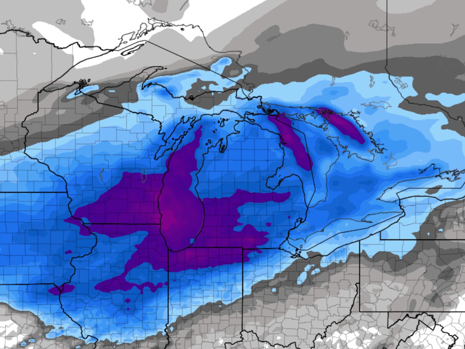
Lake-effect snow continues to impact various regions, particularly the “snow belt” areas in northwest lower Michigan, including Traverse City, Cadillac, and Big Rapids. Reports indicate “horrible” and dangerous road conditions, prompting winter storm warnings for these locations. Surrounding areas like Grand Rapids are under winter weather advisories, signaling varying conditions that could complicate travel.
Timing Is Critical: Snow Expected to Intensify
The storm is expected to begin as light snow in the southwest half of lower Michigan by early Saturday afternoon. Conditions will deteriorate quickly, becoming widespread and steady by Saturday evening. The heaviest snowfall is anticipated from Saturday night into Sunday morning, with forecasts predicting between 4 to 7 inches across most of the lower peninsula.
However, areas in the far southeast, such as Detroit and Ann Arbor, may experience a mix of rain if warmer air infiltrates the system, potentially reducing overall snowfall totals. This mixed precipitation adds another layer of complexity to travel plans during this busy holiday weekend.
Travel Advisory: Plan Ahead
Residents are advised to travel early on Saturday to avoid the storm’s peak impact, as road conditions will worsen significantly from Saturday evening through Sunday. The combination of heavy snowfall and increased holiday traffic is expected to create treacherous travel conditions, making it imperative for drivers to stay informed and plan accordingly.
A winter storm watch has already been issued for areas to the west, including Chicago and Milwaukee, as this system approaches. Authorities warn that the period from Saturday evening through Sunday afternoon will be a “mess” for travel, characterized by snow-covered, icy roads and low visibility.
Cold Snap Follows Storm: Prepare for Extended Winter
Following the storm, a significant drop in temperatures is forecasted, with cold air settling in for an extended period. Temperatures are predicted to plunge into the low 20s on Sunday, with brisk winds making conditions feel even colder. Road improvements will be slow, as the icy aftermath of the storm lingers throughout the weekend.
Meteorologists are dismissing any chance of a warm-up, urging Michiganders to brace for winter conditions that are likely to persist into early December. “We’re in it to winter it,” a local meteorologist remarked, emphasizing the need for residents to adapt to the snowy conditions.
Expert Insights: Questions About Forecast Models
In the wake of recent weather events, there is growing frustration among meteorologists regarding the performance of the U.S. Global Forecast System (GFS). Many experts believe the American model is frequently outperformed by its European counterpart, particularly for long-range forecasts. This has sparked a movement among meteorologists to advocate for improvements in U.S. weather modeling.
As this winter storm approaches, residents are encouraged to stay updated through local weather broadcasts and official sources. With the potential for severe conditions, now is the time to prepare for what could be a challenging weekend in Michigan.
Stay safe, stay informed, and share this urgent update to keep your friends and family prepared for the wintry weather ahead.