


UPDATE: Hurricane Erin has weakened to a Category 3 storm but continues to pose significant threats as it moves through the Caribbean. The National Hurricane Center reported maximum sustained winds of 125 mph in its 5 a.m. ET update.
The storm is currently located approximately 140 miles north of San Juan, Puerto Rico, and 330 miles east-southeast of Grand Turk Island, moving west-northwest at 14 mph. Residents in Puerto Rico and the U.S. Virgin Islands are experiencing heavy rain and gusty winds, with significant flash flood warnings in effect.
Rainfall estimates suggest between 3 to 6 inches has already fallen over St. John and St. Thomas, while northern Puerto Rico has recorded 2 to 4 inches. Isolated storm totals could reach 6 to 8 inches, leading to rapid flooding, landslides, and mudslides as Erin’s outer bands continue to affect these areas.
Officials have issued ongoing flash flood warnings for both Puerto Rico and the U.S. Virgin Islands, set to remain in place until Monday morning. As Erin progresses west-southwest, winds of 40 to 50 mph are expected, contributing to worsening conditions.
“The weakening of Hurricane Erin is only temporary,” stated meteorologists at the National Hurricane Center. “Re-intensification is typical following an eyewall replacement cycle.”
While conditions are predicted to improve by this afternoon in the U.S. Virgin Islands and later tonight for Puerto Rico, the storm’s outer bands will continue to impact the Turks and Caicos Islands, prompting tropical storm warnings. The southeast Bahamas is also under a tropical storm watch as Erin’s influence extends across the region.
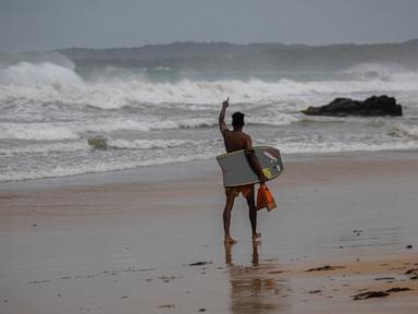
Forecast models indicate that Erin will slow down and begin shifting northward today due to a weakening Bermuda High and an incoming cold front along the East Coast. This trajectory is expected to keep direct impacts off the U.S. mainland, but dangerous surf and rip currents are anticipated along the eastern coastline, from Florida’s Space Coast to coastal New England.
Wave heights could reach 8 to 12 feet along the Carolina coastline by Thursday, raising concerns for beach erosion and safety for beachgoers.
As Erin continues to develop, authorities urge residents to remain vigilant and prepared for rapidly changing conditions. More updates are expected as the storm progresses, with the next advisory scheduled for 8 a.m. ET.