


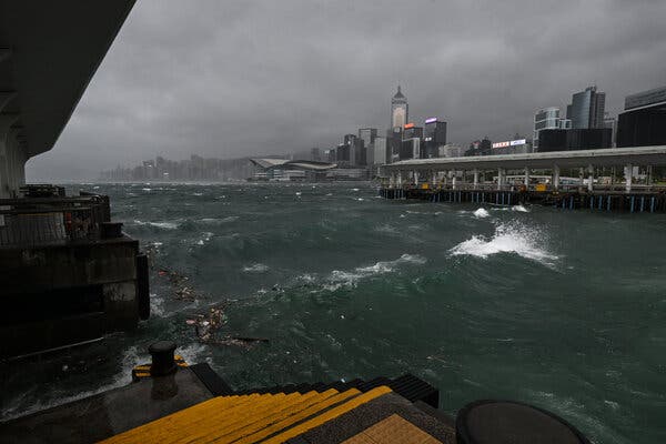
UPDATE: Typhoon Wipha is currently battering Hong Kong and Macau with relentless rain and winds reaching 106 miles per hour, as the storm approaches mainland China. This powerful storm, equivalent to a Category 2 Atlantic hurricane, is expected to intensify further as it moves west toward Macau and is forecasted to make landfall late today, October 29, 2023, between the southern Chinese cities of Shenzhen and Zhanjiang.
Authorities have issued a No. 10 hurricane signal in Hong Kong for the first time since 2023, indicating the severity of the storm. Macau has raised an equivalent alert, urging residents to seek shelter indoors and avoid windows due to the risk of flying debris. The Hong Kong Observatory has reported heavy showers and dangerous sea swells as Wipha nears.
At Hong Kong International Airport, over 400 flights have been rescheduled, while Macau International Airport has seen nearly 200 flights canceled. Local authorities are taking precautionary measures, closing workplaces, ports, and schools in response to the storm’s imminent impact.
In Zhuhai, a city of approximately 2.5 million people in Wipha’s projected path, officials have shut down construction sites, parks, and public transport services. Similar closures are reported in Zhanjiang, where schools and workplaces have been suspended.
As Wipha progresses across southern China, it is expected to move offshore again, potentially making landfall in Vietnam. Meteorological agencies are closely monitoring the storm’s trajectory, with updates being provided frequently to ensure public safety.
Residents are urged to stay tuned to local news and heed warnings from authorities. As Wipha continues to develop, its impact on infrastructure, travel, and daily life remains a pressing concern for millions in the affected regions.
Stay safe and stay informed as this situation evolves.