


UPDATE: Twin tornadoes have carved devastating parallel tracks through Tylertown, Mississippi, as a deadly superstorm unleashed over 113 tornadoes across the U.S. between March 14 and 16, 2025. The storm system, fueled by an “expansive upper-level trough,” has led to at least 42 fatalities and extensive destruction.
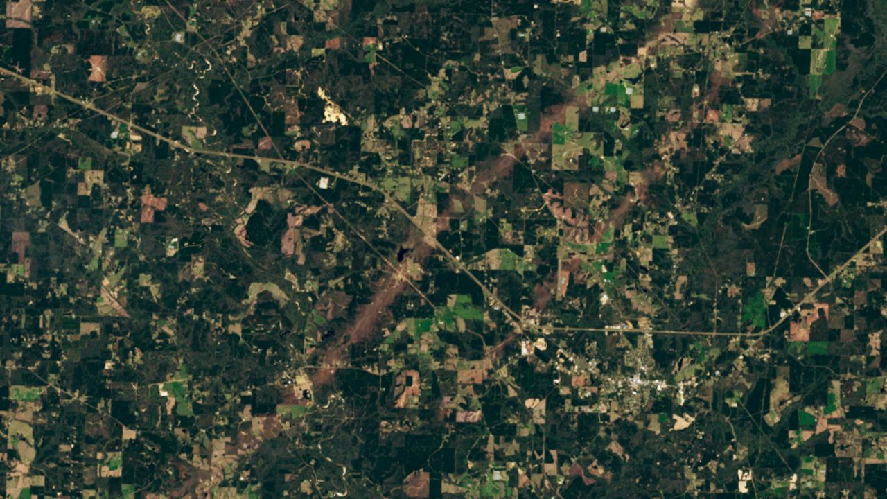
Satellite imagery from Landsat 8 reveals two tornado tracks near Tylertown, with one stretching an astonishing 55 miles (89 kilometers) and another reaching 9 miles (15 kilometers). The larger tornado is believed to have attained a Level 4 rating on the Enhanced Fujita Scale, with wind speeds estimated at 170 mph (274 km/h), equivalent to a Category 5 hurricane.
The Mississippi Emergency Management Agency reports that approximately 1,000 houses were damaged statewide, with significant impacts on local businesses and farms. This catastrophic weather event is part of a record-breaking month, with 299 tornadoes recorded in March 2025 alone, a dramatic increase from the average of 80 tornadoes typically seen in March.
Why This Matters NOW
As the storm system wreaks havoc, Mississippi stands out as one of the hardest-hit states, experiencing 18 tornadoes, with half classified as causing “considerable damage.” The urgency of this situation is underscored by aerial photographs showing the aftermath of the tornadoes, including another pair of tornadoes that crossed paths at right angles, creating an alarming X-shape in Covington County.
Authorities stress the need for immediate awareness and preparedness, as conditions conducive to tornado formation continue to persist. The National Weather Service in Jackson, Mississippi, is actively monitoring the situation and providing updates on recovery efforts and safety measures.
What’s Next?
Looking ahead, experts are warning that 2025 could be one of the most active years for tornadoes in recent memory. The ongoing influence of the La Niña phenomenon is altering weather patterns, contributing to the increased tornado frequency. Climate change is also playing a significant role, as rising sea surface temperatures are believed to be making tornadoes more intense and deadly.
With the potential for tornadoes to strike regions not traditionally known for such events, researchers at NASA are exploring new predictive technologies that may provide up to 10 minutes of warning before a tornado strikes. This could be crucial in saving lives as communities continue to face the devastating impacts of extreme weather.
Residents are urged to stay vigilant and follow local advisories as recovery efforts begin. The emotional toll of these disasters is profound, and communities are coming together to support those affected.
As this story develops, stay tuned for updates on recovery efforts and safety measures being implemented across the impacted regions.