


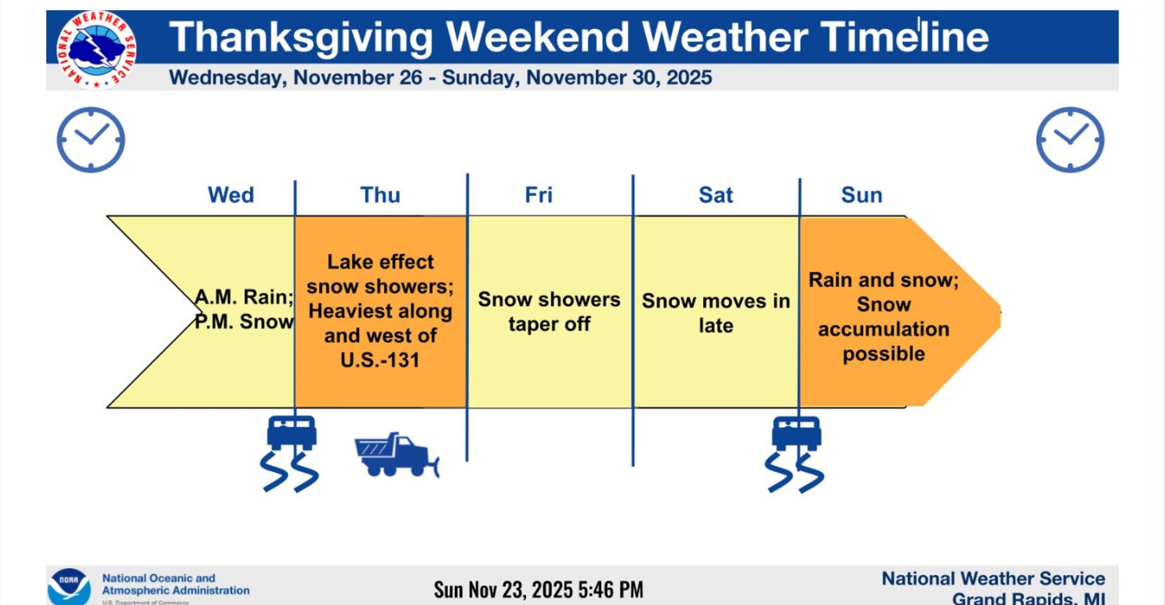
UPDATE: A powerful winter storm is poised to wreak havoc on Thanksgiving travel across Michigan as severe weather conditions develop just in time for the holiday. Meteorologists from the National Weather Service (NWS) are warning of significant snowfall, strong winds, and hazardous road conditions beginning Wednesday evening.
Starting with mild temperatures on Monday, Michigan residents can expect a quick shift as rain moves in overnight. By Wednesday, the forecast turns dire, with temperatures plummeting and rain transitioning to snow throughout the day. Areas from Cadillac to Gaylord and north into Petoskey are predicted to experience the heaviest snowfall, with accumulations potentially exceeding 6 inches in some regions.
The NWS forecasts sustained wind gusts of up to 45 mph, creating blustery conditions that will severely impact visibility and driving. “Once the cold air slams in, it’ll be here through the weekend with highs in the mid 30s,” warned NWS meteorologists in Grand Rapids, emphasizing the potential for dangerous travel conditions starting Wednesday night.
The storm is expected to bring heavy snowfall rates of 1 to 2 inches per hour, particularly in organized bands, combined with wind gusts of 30 to 45 mph. This combination could lead to blinding snow and drifting, making travel extremely hazardous. In addition to snowfall, there is a risk of power outages due to the heavy, wet snow combined with high winds.
For the southern half of the Lower Peninsula, lake-effect snow is likely on Thanksgiving Day, especially along and west of U.S. 131. The NWS indicates that snow showers will continue into Friday, adding to the already challenging travel conditions.
Wave heights on Lake Superior are expected to rise dramatically, reaching up to 16 feet in some areas, prompting gale warnings for Wednesday and Thursday with winds up to 45 knots. Residents near the Keweenaw Peninsula may experience particularly severe conditions.
As families prepare for holiday gatherings, the NWS advises caution for anyone traveling during this period. “The potential impacts from forecast winds cannot be understated,” the Gaylord office noted, warning that rapid drops in visibility could occur alongside dangerous road conditions, particularly on north-south oriented highways.
Looking ahead, the forecast indicates that another storm system could affect Michigan during the weekend, adding further uncertainty to travel plans. Residents are urged to stay updated on weather developments and prepare for potentially treacherous conditions as Thanksgiving approaches.
As this winter storm rapidly approaches, the situation remains fluid. Stay tuned for further updates on this developing story to ensure your safety and that of your loved ones during the holiday travel rush.