


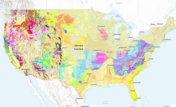
A comprehensive new map released by the U.S. Geological Survey (USGS) provides an interactive tool for users to explore the types of rocks and sediments beneath the Earth’s surface. Unveiled in August 2023, this map is the result of three years of dedicated research and builds upon decades of geological mapping efforts.
The innovative tool allows users to view the ages and characteristics of geological units, which are organized by shared traits such as composition and age. Users can search for specific geological properties or click on sections of the map to access additional information, links, and more detailed local maps.
Joseph Colgan, a research geologist with the USGS and leader of the mapping team, explained the significance of this resource: “This map provides complete, analysis-ready geologic data for the nation, in a format that is easy to expand going forward.” He emphasized that making this map available online aims to enhance educational engagement and foster greater public appreciation of geology.
A key advancement in this mapping project was the development of a faster, mostly automated solution that integrates geological maps from various state geological surveys and the USGS. This method significantly reduced the time required to create a map of such scale, allowing researchers to complete the project in a fraction of the usual time.
Revolutionizing Geological Exploration
This mapping initiative is part of an ongoing collaboration between the Association of American State Geologists and the National Geologic Map Database. Sam Johnstone, a USGS research geologist and lead developer of the project, noted the advantages of the new method: “Ongoing mapping efforts continually make new discoveries, but past national maps took decades to create, while our new method allows us to update our national map faster than ever before.”
The USGS has indicated that this map serves a diverse audience, from the general public to professionals in the field. Experts have already begun to identify potential applications for the map. Christopher Swezey, the USGS National Cooperative Geologic Mapping Program coordinator, highlighted its utility: “Geologic maps have many uses, such as helping experts look for energy, mineral, and water resources. They can also be used to assess earthquake risks and inform decisions about land use, infrastructure, community planning, and real estate insurance.”
Despite its advancements, the map is still a work in progress. According to Eos.org, disparities in geological data collection and publication persist, with the Idaho-Washington border exemplifying these inconsistencies. Each state has provided different information regarding the rock layers near their shared border.
Johnstone acknowledged these challenges, stating, “Such disparities are unavoidable on the new map. The goal was to integrate data without altering the original maps’ interpretations.” He pointed out that these differences highlight opportunities for future collaboration across state agencies and with the USGS, ultimately strengthening the accuracy and consistency of geological data nationwide.
As this map continues to evolve, it promises to deepen understanding of the geological landscape beneath our feet, enhancing both education and practical applications in various fields.